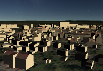
 Nowadays more and more important thing is to present surrounding us reality in the most realistic way. Cities all over the world reach for the latest developments in the field of geoinformatics, by using a realistic and useful visualization to attract the attention of tourists, as well as to facilitate communication and the exchange of information between officials and people of the region. It makes people feel more needed and more likely to engage in the development of their environment and community.
To meet customer expectations, the company ProGea Consulting offers the possibility of making a realistic, three-dimensional models of cities. Using the point cloud and aerial photos (both vertical and oblique), and enriching them with elevation pictures, we can make real city models with different levels of detail, according to the guidelines defined in the general accepted standard CityGML. It is based on international data exchange format and encoding Geography Markup Language (GML) used to model 3D cities released by the OGC (Open Geospatial Consortium).

Depending on the order in which objects are created, there are different levels of accuracy. CityGML defines five levels of detail for city models:
- LoD0 – digital terrain model covered with orthophotomap;
- LoD1 – model of a simple shape buildings without presenting roof (all flat roofs);
- LOD2- city model with roof structures and simple textures;
- LoD3 – LOD2 level model enhanced with high-resolution textures and architectural detail of facades and roofs;
- LoD4 – includes a very detailed architectural model allowing for visualization of both the inside and outside of buildings.
We export 3D building models to external formats such as Collada (.Dae), Google Earth (*. Kmz).

Our cooperation with the Swedish Agency 9 gives us an opportunity to create an interactive platform to visualize three-dimensional models of cities.
City Planner is a 3D geo-portal, ready-made solution adapted to the wide needs of urban management. It allows to visualize and share 3D city projects, planned investments and Municipal Land Use Plans.
CityPlanner Agency 9 portals:
- http://cityplanneronline.com/cityplanner/project/index.do?uid=NZgr8InK
- https://cityplanneronline.com/cityplanner/project/index.do?uid=vbYcugSh
3Dmaps is an application available through the Internet (using Java and JavaScript) and allows you to visualize:
- 3D city models,
- Terrain models DTM and DSM,
- Oblique aerial photos
- Orthophotomaps
- Spatial data (ESRI Shapefile)
- Supports WMS service,
- Manages the POI.
3Dmaps services:
Progea Consulting Company has developed 3D city – Zory. Models of buildings have been constructed on the basis of LiDAR data from the project ISOK. More information about the project and our technology you can find here.
If you want us to carry out a project of 3D city – contact us.

